|
Published on Archi.ru (https://archi.ru) |
|
| 09.10.2023 | |
|
Harmonization of Intentions |
|
|
Alyona Kuznetsova |
|
| Studio: | |
| Genplan Institute of Moscow | |
|
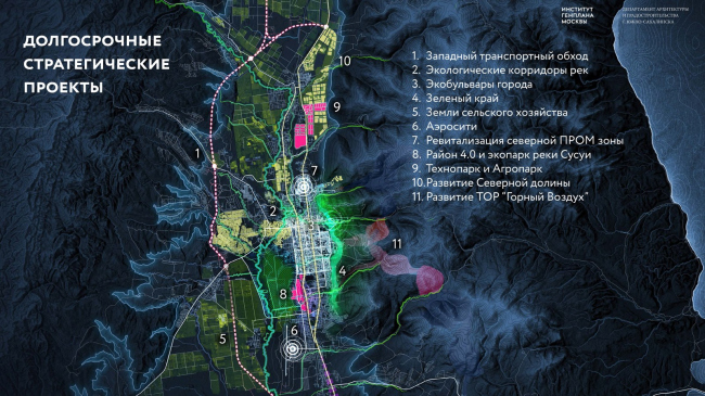
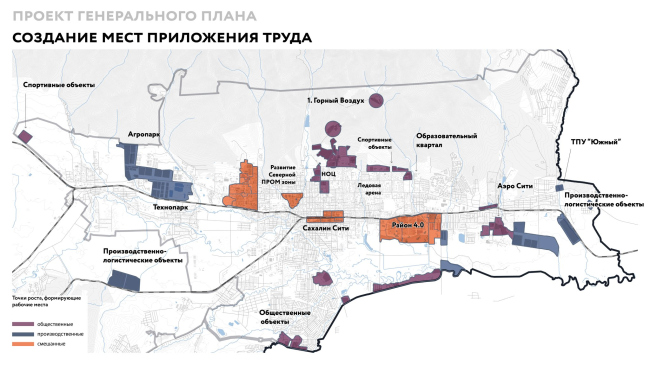
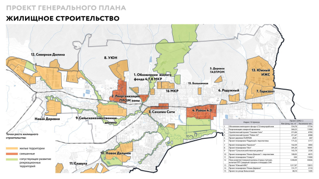
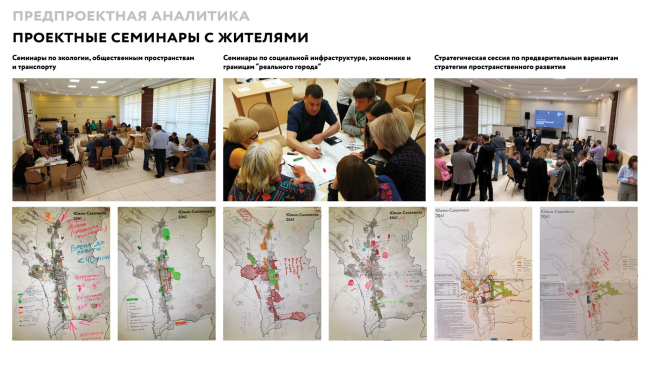
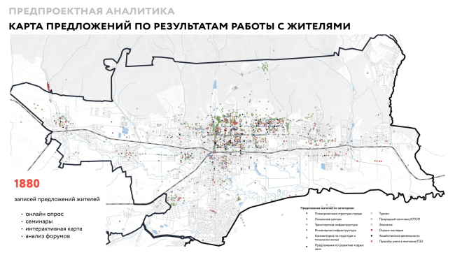
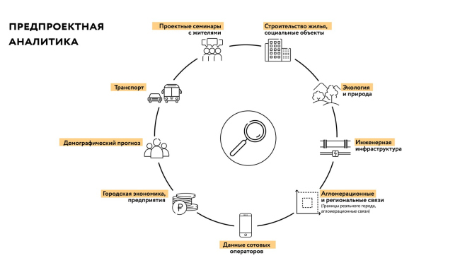
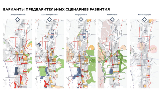
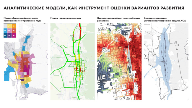
We met and talked with the chief architect of Genplan Institute of Moscow Grigory Mustafin and the chief architect of Yuzhno-Sakhalinsk Maxim Efanov – about how the master plan of the city is formed. The key to success: gathering data, digital simulation, working with the city people, thinking infrastructure, and presentation. Archi.ru Long-term strategic projectsCopyright: © Image provided by Yuzhno-Sakhalinsk Department of Architecture and Urban PlanningMaxim Efanov, Chief Architect of Yuzhno-Sakhalinsk: In the spatial strategy, we tried out several projects: for example, we started to form land plots for the production of liquefied natural gas. We passed this stage within the framework of the Skolkovo program for training management personnel for the 100 largest Russian cities: we voiced our ideas in presentations and received feedback. And in the process of approving the master plan, we realized that we had additional local tasks and made adjustments. In a word, it is a living and breathing document. Quite large functional zoning gives us a lot of flexibility, and the land use and development rules allow us to fine-tune the details. Grigory Mustafin: If we trace how the requirements for the development of master plans from the 10th order were implemented, we will see that the developers of master plans are gradually moving from a full classifier of functional zoning of 30 names to increasingly larger zones, which include flexible levers to respond to changing external settings. 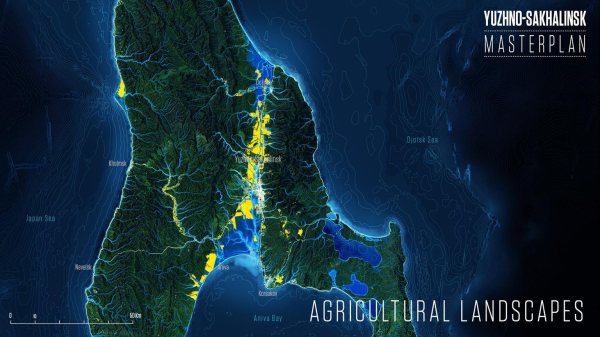 Agricultural landCopyright: © Image provided by Yuzhno-Sakhalinsk Department of Architecture and Urban Planning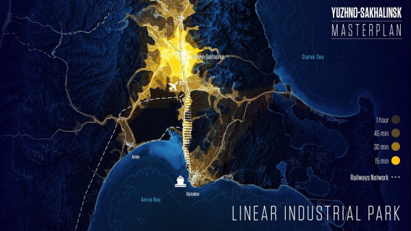 Linear industrial parkCopyright: © Image provided by Yuzhno-Sakhalinsk Department of Architecture and Urban Planning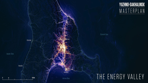 The Energy ValleyCopyright: © Image provided by Yuzhno-Sakhalinsk Department of Architecture and Urban PlanningIs this the reason that Yuzhno-Sakhalinsk needed a new master plan so urgently? The previous one was only adopted in 2012? Maxim Efanov: The master plan is usually adopted for 20 years, but over this time everything changes, right down to urban planning legislation. In the previous master plan there were no investment projects that we are currently implementing. And in order to form land plots for them, there must be an appropriate type of permitted use. And even if a land plot was formed, we have no infrastructure for it: engineering networks, highways. Simply repainting zones – that’s not how it works. Every three years the master plan definitely needs to be adjusted. As we have already said, it is a living document. Grigory Mustafin: The new Master Plan has been prepared in accordance with the new legislative requirements, including those for design. The socio-economic development of Yuzhno-Sakhalinsk has also had a significant impact on it. We have updated several issues: for example, the previous master plan included the areas of the Ministry of Defense and forestry, and the road was routed through a few “forbidden” areas. We analyzed every conflict of interests and proposed alternatives. A big block of work in the creation of the master plan is the harmonization of intentions and clarification of priorities of the city development. How do you monitor the actual implementation of the master plan? Maxim Efanov: A special division of the Department of Architecture and Urban Planning together with the Department of Economic Development is in charge of monitoring urban planning documentation. Having approved the draft master plan, we make sure that the development moves in the vector it was designed for. This is a long-term day-to-day work: to select a land plot, to analyze vacant territories and put them up for auction, to help the land use department to form tender documentation, to determine the parameters of the territory. Which solutions of the master plan for Yuzhno-Sakhalinsk are already being implemented, and which are in the pipeline? How do you establish your implementation priorities? Maxim Efanov: Yuzhno-Sakhalinsk now has an overland metro. The previous master plan envisioned taking the railroad outside the city center, but now the approach to this issue has been revised: the railroad has become the basis for the development of the surface metro. Rail buses are used as high-speed public transportation that does not stand in traffic jams and is not afraid of snow drifts and snowstorms. The entire city transportation network is now formed on the basis of the existing railroad: several interchange hubs have already been opened, and together with Russian Railways we have changed the schedule of freight traffic so as not to interfere with the movement of public transport. Demand for railroads has been growing by multiples every year since the launch. The bet has played out. Grigory Mustafin: To support this story, we have put into perspective the development of the territory around the surface metro stations in order to capitalize this infrastructure. Renovation of the industrial zone with the creation of a new urban center, development of industrial technoparks, agro-parks, new residential areas are “tied” to the railroad. The alternation of residential areas and economic clusters makes it possible to move towards the concept of a “15-minute city”. Creation of places of labor applicationCopyright: © Image provided by Yuzhno-Sakhalinsk Department of Architecture and Urban PlanningHousing constructionCopyright: © Image provided by Yuzhno-Sakhalinsk Department of Architecture and Urban PlanningMaxim Efanov: It is also worth mentioning that until 2018, Yuzhno-Sakhalinsk had only a narrow-gauge railroad; now it has been “revamped” but not electrified. The rail buses are modern, comfortable, but they run on a diesel engine. Together with PJSC RusHydro, we have launched a program to switch the rail bus to hydrogen fuel, and the same is expected for the rest of the transport, which is now gasified at the expense of the regional subsidy. We are striving for carbon neutrality. Grigory Mustafin: Our colleagues have chosen a very productive approach: first they invested in transportation, then they developed the territory itself. It is very rare for our cities to have such a well-organized urban planning activity. What other interesting things can you mention? Maxim Efanov: The master plan of the northern industrial zone is ready, this year we plan to do a lottery for the “integrated land development” program. The “UYUN” and “Horizon” micro-districts are under construction, the “Field of Miracles” micro-district has been designed, the first stage of construction of a technopark, an agro-park, an airstrip, a western bypass road of regional significance, a scientific and educational center, a campus for 1500 students has begun. All this was from the very start included in the spatial development strategy and master plan. These adjustments to the master plan – do they come mostly from “above” or from “below”? Maxim Efanov: The municipality, of course, understands where housing should be developed and where industry should be developed. But there are nuances that residents know much better. For example, we discussed in detail with the citizens four options for the alignment of the western bypass and the so-called eastern bypass street: we met, discussed the pros and cons, made decisions at the management level and adjusted the master plan in the way we agreed with the residents. Thus, we removed a large block of tension. The number of appeals about violation of citizens’ rights in urban documentation has significantly decreased. Opinion poll in Yuzhno-SakhalinskCopyright: © Image provided by Yuzhno-Sakhalinsk Department of Architecture and Urban PlanningGrigory Mustafin: This was an initiative of the client and us as a contractor – the legislation provides for interaction with residents only at the very last stages during public hearings. Our colleagues in the terms of reference for the development of documentation included a separate stage for this: telephone and internet surveys were conducted, a platform with a map where you could leave an idea worked, seminars about transportation and the natural framework were held. We literally sat in circles and drew schemes of possible city development. Then we would come separately and show them – this is what we have fixed, what goes into the concept. And then iterations. There were projects in our practice, where less work was done, and it was felt at public hearings. We also met individually with businesses and investors. It would be correct to scale this experience to other cities in our country. Map of proposals based on the results of work with residents of Yuzhno-SakhalinskCopyright: © Image provided by Yuzhno-Sakhalinsk Department of Architecture and Urban PlanningThe Genplan Institute of Moscow has developed a “System of Complex Indicators of Urban Environment Assessment” – how does it help in creating a master plan? Grigory Mustafin: There is a certain algorithm in the development of any territorial and strategic planning document. Everything starts with data collection work, which in fact never stops: even by the time the master pan is approved, we continue to receive various data from executive authorities, residents, and other sources. Pre-project analyticsCopyright: © Image provided by Yuzhno-Sakhalinsk Department of Architecture and Urban PlanningYour data is information, but information does not automantically equal meaning. Using complex algorithms, we verify the data and turn them into a basis for creating a project solution: we identify problems, potentials, and drivers of territory development. That is, we turn facts into value judgments. Further we do not say: “here is the final correct solution for the development of the city”. Instead, we consider several scenarios: if we do nothing, if we emphasize agglomeration development, or if we invest all investments in the city center. We have made five such scenarios for Yuzhno-Sakhalinsk. Options of preliminary development scenarios for Yuzhno-SakhalinskCopyright: © Image provided by Yuzhno-Sakhalinsk Department of Architecture and Urban PlanningFurther on, we use this information for modeling apparatus and apply tools that would help to characterize the scenario from an unexpected side, to show the pitfalls. In this process, we try to identify the maximum number of objective pros and cons. And after that we choose either the best scenario or combine the “hits” from all variants. Analytical models as a tool for assessing development optionsCopyright: © Image provided by Yuzhno-Sakhalinsk Department of Architecture and Urban PlanningAfter the selection of the scenario follows nuanced work and refinement. This stage is also accompanied by modeling: we check how the changes affect the load of infrastructure, the provision of residents with certain resources. This tool is also convenient for approvals. Is the algorithm the same for working with all cities? Grigory Mustafin: There are nuances. The data is organized differently, the assessment tools differ: somewhere it is related to landscape characteristics, somewhere – to historical and cultural heritage. We try to transform the template in such a way that it is customized to the uniqueness of the city. For example, in Sevastopol, an important factor influencing all decisions is the relief: the city territory is located on terraces, beams, ridges, and you have to take into account the view of the sea – all this affects functional zoning. In the case of Yuzhno-Sakhalinsk, especially in the case of the master plan, a lot of attention is paid to the presentation of the work – videos, layouts, infographics, discussion at the Eastern Economic Forum. How important is this part of the work? Maxim Efanov: The presentation made by the Institute of General Plan together with IND architects on the first belt of the Yuzhno-Sakhalinsk agglomeration is beyond praise. This is exactly the kind of presentation that is needed to bring numbers, maps, and schemes to the attention of managers and residents, and to show and justify that your project is successful. Grigory Mustafin: It should be remembered that the master plan for the Yuzhno-Sakhalinsk agglomeration and other Far Eastern cities was prepared at a different level, by order of the President. And this is unprecedented: it is the first time in the history of master planning that such a large-scale initiative from the federal government has appeared. The level of involvement of regional governments and federal executive bodies was very high. When we were developing the master plan, we regularly prepared materials for private presentations and discussed them separately with Maxim Oreshkin and Yuri Trutnev. At one point, the jury looked at 10 master plans at once. Then the master plans were reviewed by the President and currently some of them, including Yuzhno-Sakhalinsk, have already been approved and are receiving support. We wanted to showcase the region to the best advantage. We made a 15-minute video with 170 slides, which covered absolutely everything – initiatives, agreements, strategic projects, drivers of economic development. We also made a shorter video with infographics, 3D visualizations, in which we translated the figures understandable to specialists into human language. Then we presented them at the Eastern Economic Forum. In May 2023, the master plan was presented to the president and approved. After that, special decrees were issued to support infrastructure projects. Let’s summarize: what is the formula for a viable master plan? Grigory Mustafin: The first thing is interaction with residents, starting from the stage of forming the first conceptual decisions. The second is an emphasis on infrastructure development: instead of building a residential area in a field, it is necessary to develop high-speed transportation and focus priority projects on it, taking into account the strategic goals. The third is to alternate residential areas with economic clusters. In Yuzhno-Sakhalinsk, this is, for example, an agro-park, which affects the improvement of the island’s food security, the external economic framework, and the possibility of exporting to other regions. These three things mean a high quality master plan for any city, regardless of its geographic location. |
|
